Skip to content
  • Map
  • Route Finder
  • Route Planner
  • Travel Guide
  • Community
Sign up or log in
  • Map
  • Route Finder
  • Route Planner
  • Travel Guide
  • Community
Sign up
  • Places & Accommodation
    • Places to visit
    • Eat & drink
    • Huts
    • Accommodation
    • Ski resorts
    • Crags
  • News & Conditions
    • Current Conditions
    • Weather
    • Webcams
    • Avalanche Report
    • Events
  • Inspiration
    • Collections
    • Offers
    • Travel Stories
    • Publications
  • Community
    • Challenges
    • Groups
  • Settings
  • Help-Center
  • Terms and conditions
  • Privacy policy
  • Legal Disclosure
Travel Guide Hungary Nyugat-Dunántúl Őrségi Nemzeti Park
more
  • Kétvölgy
    Kétvölgy Photo: Lánczi Péter, Magyar Természetjáró Szövetség

Őrségi Nemzeti Park

A national park is a park in use for conservation purposes. Often it is a reserve of natural, semi-natural, or developed land that a sovereign state declares or owns.

Area: 442.11 km²
Find out more
Digitize the Planet e.V.  Verified partner 
Author of this page
LogoDigitize the Planet e.V.

Activities in Őrségi Nemzeti Park


European bison in Pityerszer
hikes
bike rides
bikepacking routes
mountain biking trails
road cycling routes
long-distance hikes
pilgrim walks motorcycle routes

Attractions in Őrségi Nemzeti Park


Highlights

  • My Map
  • Content
  • Show images Hide images
Features
Maps and trails
Discover
Hiking Trail · Őrségi Nemzeti Park
Bison ronda tour from Szalafő
Toprecommended route Difficulty moderate
Distance 14.3 km
Duration 3:35 h
Ascent 97 m
Descent 97 m

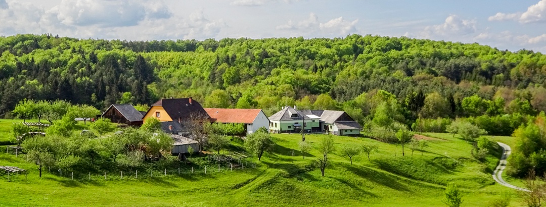
Wandering in the magical world of Szalafő’s Szerek, we marvel at the farmsteads blending into the landscape and the atmosphere of mowing orchards.

7
from Kevy Albert,   Magyar Természetjáró Szövetség
Hiking Trail · Őrségi Nemzeti Park
From settlement to settlement along the "Szala"
Toprecommended route Difficulty moderate
Distance 18.5 km
Duration 4:40 h
Ascent 141 m
Descent 148 m

We stroll along the landscape-integrating settlements of Őriszentpéter and Szalafő by the Szala river. Along the way, we explore the meadows and ...

1
from Kevy Albert,   Magyar Természetjáró Szövetség
Hiking Trail · Őrségi Nemzeti Park
From Őrimagyarósd to the Szőce fen
Toprecommended route Difficulty easy
Distance 7.6 km
Duration 1:55 h
Ascent 20 m
Descent 7 m

We hike on a forest nature trail, stepping on the boardwalk gaining insight into the peculiar world of the fens. We can admire the bird eggs of ...

3
from Kevy Albert,   Magyar Természetjáró Szövetség
Hiking Trail · Vasi-Hegyhát
Circular hike along the Slovenian settlements of Hungary into the heart of Vendvidék
Toprecommended route Difficulty easy Open
Distance 17.2 km
Duration 4:30 h
Ascent 287 m
Descent 287 m

Forest walk to the center of Vendvidék, Kétfalu, from the Rába valley, seasoned with the western point and the meadow orchids educational trail.

3
from Német-Bucsi Attila,   Magyar Természetjáró Szövetség
Long-Distance Hiking · Zalai-dombság
Őriszentpéter – Zalalövő (DDK-03)
Toprecommended route Difficulty difficult Stage 3 Open
Distance 54.2 km
Duration 14:40 h
Ascent 670 m
Descent 710 m

This section mostly winds between the villages of Őrség in Vas county, separated by low hills. Crossing into Zala, we walk through sparsely ...

4
from Imre Bába,   Magyar Természetjáró Szövetség
Hiking Trail · Őrségi Nemzeti Park
Across Countries - Circular Route at Hármashatár
Toprecommended route Difficulty T1 moderate
Distance 17.8 km
Duration 4:50 h
Ascent 290 m
Descent 288 m

We explore the most beautiful parts of the Hármashatár, the protected areas of three countries. We climb Hármashatár-hegy, immerse ourselves in ...

9
from Kevy Albert,   Magyar Természetjáró Szövetség
Bike Riding · Őrségi Nemzeti Park
The best of the diverse Őrség landscape
Toprecommended route Difficulty moderate
Distance 39.1 km
Duration 3:00 h
Ascent 406 m
Descent 388 m

The hilly, varied Őrség landscape is an excellent cycling tour terrain, as most of the roads are low-traffic public roads, with a constantly ...

2
from _ MTSZ,   MTSZ - együttműködő szervezetek
Hiking Trail · Nyugat-Dunántúl
Keserűszer - Pityerszer along the Hungarian-Slovenian border
Toprecommended route Difficulty easy Open
Distance 8.4 km
Duration 2:25 h
Ascent 77 m
Descent 12 m

This route is short yet unlimited. You can explore a slice of the 'roles' of Őrség here, where you can immerse yourself in the dense forests, walk ...

7
from Hegedűs Regina,   Magyar Természetjáró Szövetség
Hiking Trail · Őrségi Nemzeti Park
Along waters, deep in forests
Toprecommended route Difficulty easy
Distance 14.3 km
Duration 3:35 h
Ascent 66 m
Descent 11 m

The Rába region, the picturesque valley of the Lugos Creek, the unspoiled forests of Őrség, and the hidden memories within them, combined with the ...

from Kevy Albert,   Magyar Természetjáró Szövetség
Hiking Trail · Őrségi Nemzeti Park
Túra a gölöncsérek földjén
Toprecommended route Difficulty moderate
Distance 18.1 km
Duration 4:35 h
Ascent 191 m
Descent 191 m

A Belső-Őrség falvai között festői környezetben barangolunk, ismerkedve a fazekas hagyományokkal, erdők, mezők élővilágával, a veleméri templom ...

4
from Kevy Albert,   Magyar Természetjáró Szövetség
Discover more
  • My Map
  • Content
  • Show images Hide images
Features
Maps and trails
Discover

Discover the region

Accommodation
places to eat and drink

Trip planning


Weather

10-day forecast

Reviews

  108
From settlement to settlement along the "Szala" by Balázs
September 06, 2025 · Community
Az Őrség egyébként is egy szép tájegység, akár motoron, akár autóval jár arra ez ember, de ez a túra újabb részleteket nyitott ki. Sárdagasztás alig volt, jobbára tömör földúton, murvás úton, szántón és műúton vezet, nem nehezíti a sétát dzsungel sehol. Nem olvastam el az útleírást szokás szerint, így meglepődtem, amikor a túra végére értem Szalafőn. Onnan még gyalogolnom kellett Őriszentpéterre, mert ott parkoltam, az iskola közelében. Ki szerettem volna próbálni a sajtautomatát, de jelenleg nem üzemel, plusz belefutottam egy több kilométeres veteránjármű felvonulásba így csak kerülővel tudtam távozni. Összesen 27 km-t tettem így meg gyalog.
More Show less
Route done on September 06, 2025
Comment
Kilátásos körút a Z Vasfüggöny túraúton (Rajka – Felsőszölnök – Gyékényes) Felsőszölnök felett Trdkova ekkor: 2025. augusztus 7 by Márti
August 07, 2025 · Community
Végig teljesen jól járható útvonal.
More Show less
Comment
Tour in the forest of Szentgotthárd Abbey, in the scattered settlements of the Vendek by Balázs
August 06, 2025 · Community
Kellemes túra volt. Megjegyzendő, hogy a legelső szakasza fokozottan védett terület, melyhez elvileg engedély szükséges, de ez a szakasz amúgy nem hosszú. Hosszú ruhában érdemes jönni, ha az ember szeretné ép bőrrel teljesíteni, nem árt a bakancs sem, mert itt-ott nagy és kiterjedt a sár, bár nekem sikerült cipőben is. Farkasfán egy kerítés nélküli udvarról mellém szegődött egy fekete-fehér kutya, nem kell tőle félni, jó arc, elkísért a kereszteződésig.
More Show less
Route done on August 06, 2025
Comment
Show more Show less

Destinations in Őrségi Nemzeti Park


Nature regions

  • Great mountain range
    Alps
  • Mountain range
    PreAlps East of the Mur
  • Mountain range
    Vasi-Hegyhát
App Store
Google Play Store
Huawei App Gallery
  • Our services
    • Features
    • Subscriptions
    • Pro for Search & Rescue
    • Enjoy great benefits and discounts from our partners
    • Vouchers
    • B2B
  • More services
    • Help Center
    • Blog (German only)
    • Newsletter
    • Affiliate Program
    • Contact Us
  • Corporate
    • Discover Outdooractive
    • Outdooractive30
    • Careers
    • Outdooractive Business
Learn more about the apps for Android and iOS
1% for the Planet
Choose a language
English
  • Deutsch
  • italiano
  • français
  • español
  • עברית
  • 中文
  • română
  • português (Portugal)
  • português (Brasil)
  • čeština
  • suomi
  • русский
  • magyar
  • norsk bokmål
  • slovenčina
  • Nederlands
  • 日本語
  • українська
  • हिन्दी
  • Türkçe
  • Ελληνικά
  • Mobile version
  • Terms and conditions
  • Privacy policy
  • Cancellation policy
  • Customer information
  • Terms of payment
  • Map information
  • Legal Disclosure
  • Accessibility