Skip to content
  • Map
  • Route Finder
  • Route Planner
  • Travel Guide
  • Community
Sign up or log in
  • Map
  • Route Finder
  • Route Planner
  • Travel Guide
  • Community
Sign up
  • Places & Accommodation
    • Places to visit
    • Eat & drink
    • Huts
    • Accommodation
    • Ski resorts
    • Crags
  • News & Conditions
    • Current Conditions
    • Weather
    • Webcams
    • Avalanche Report
    • Events
  • Inspiration
    • Collections
    • Offers
    • Travel Stories
    • Publications
  • Community
    • Challenges
    • Groups
  • Settings
  • Help-Center
  • Terms and conditions
  • Privacy policy
  • Legal Disclosure
Travel Guide Kaiserstuhl
more
  • Scenic landscape in the Kaiserstuhl area
    Scenic landscape in the Kaiserstuhl area Photo: Peter H, pixabay.com
  • Spring in the Kaiserstuhl: Blossoming cherry trees
    Spring in the Kaiserstuhl: Blossoming cherry trees Photo: Couleur, pixabay.com
  • Vineyards in the Kaiserstuhl
    Vineyards in the Kaiserstuhl Photo: Zotx, pixabay.com
  • Green hills in the Kaiserstuhl Photo: Achim Ruhnau, pixabay.com

Kaiserstuhl

The Kaiserstuhl is a small low mountain range in Breisgau, directly on the Rhine and on the border with France. The Breisgau is also called the 'Gateway of Spring' and is considered the warmest region in Germany. Its mild climate offers the best conditions for vineyards and makes the Kaiserstuhl a habitat for numerous warmth-loving plants and animals. The outstanding biodiversity is protected in no less than 16 nature reserves, which you can explore on beautiful hiking trails.
Find out more
Outdooractive Editors  Verified partner 
Author of this page

Activities in the Kaiserstuhl area


hikes
bike rides
road cycling routes
mountain biking trails
bikepacking routes
motorcycle routes
long-distance hikes nature trails gravel bike routes

Attractions in the Kaiserstuhl area


Highlights

  • My Map
  • Content
  • Show images Hide images
Features
Maps and trails
Discover
Hiking Trail · Kaiserstuhl
Ridge hike around Vogtsburg im Kaiserstuhl
Toprecommended route Difficulty T2 difficult
Distance 19.2 km
Duration 6:00 h
Ascent 650 m
Descent 650 m

Scenic high-altitude hike from Oberrotweil to Katharinenberg, Eichelspitze, and Totenkopf.

13
from Walter Biselli,   Walter Biselli
Hiking Trail · Kaiserstuhl
King's route in the Kaiserstuhl - Neunlindenturm and Eichelspitzturm
Toprecommended route Difficulty easy
Distance 10 km
Duration 3:10 h
Ascent 510 m
Descent 510 m

Over the highest elevations in the small volcanic mountain range

6
from Matthias Schopp / Gunter Schön,   Schwarzwaldverein e.V.
Road Cycling · The Black Forest
Road bike route Kaiserstuhl over Texas Pass from Badenweiler
Toprecommended route Difficulty moderate
Distance 111.1 km
Duration 4:30 h
Ascent 1,341 m
Descent 1,328 m

Kaiserstuhl road bike route over the legendary Texas Pass.

2
from Felix Odebrecht,   Badenweiler
Road Cycling · The Black Forest
Road bike route to Breisach and around the Kaiserstuhl from Badenweiler
Toprecommended route Difficulty difficult
Distance 122 km
Duration 5:30 h
Ascent 692 m
Descent 707 m

Dreamlike road bike route around the Kaiserstuhl with little elevation.

1
from Felix Odebrecht,   Badenweiler
Hiking Trail · Kaiserstuhl
Eichelspitze – On the Geopath to the second highest Kaiserstuhl peak
Toprecommended route Difficulty easy Open
Distance 15.7 km
Duration 4:30 h
Ascent 440 m
Descent 440 m

The Geo-Route to the Eichelspitze takes us on the traces of the landscape history in the Kaiserstuhl: From volcanism to viticulture, exciting facts ...

3
from Matthias Schopp / Gunter Schön,   Schwarzwaldverein e.V.
Hiking Trail · Kaiserstuhl
Kaiserstuhl trail
PremiumPremium content Difficulty difficult
Distance 22.2 km
Duration 7:00 h
Ascent 706 m
Descent 690 m

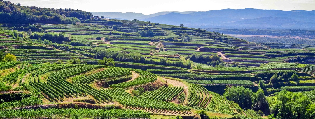
The Kaiserstuhl lies between the Black Forest and the Vosges. You can hike through the small low mountain range on the Kaiserstuhl trail.

from Jochen Ihle,   Tourenplaner SCHWEIZ - Partner für Wandertouren
Hiking Trail · Kaiserstuhl
Kammwanderung um Vogtsburg im Kaiserstuhl über Rasthaus Lenzenberg
Toprecommended route Difficulty T2 difficult
Distance 25.4 km
Duration 7:40 h
Ascent 750 m
Descent 750 m

Anspruchsvolle Variante der aussichtsreichen Höhenwanderung von Oberrotweil auf den Katharinenberg, zum Eichelspitzturm und Neunlindenturm; zurück ...

from Walter Biselli,   Walter Biselli
Bike Riding · The Black Forest
Upper Rhine Roman Cycle Route through Markgräflerland and Kaiserstuhl
Toprecommended route Difficulty moderate
Distance 138.9 km
Duration 10:47 h
Ascent 1,131 m
Descent 1,199 m

By bicycle on a historic route through the Markgräflerland and the Breisgau.

from Felix Odebrecht,   Badenweiler
Hiking Trail · Kaiserstuhl
Cherry tree path along the Kaiserstuhl: from Sasbach to Endingen
Toprecommended route Difficulty T1 moderate
Distance 13.8 km
Duration 4:00 h
Ascent 375 m
Descent 375 m

The cherry tree trail leads through the picturesque nature of the northern Kaiserstuhl, where magnificent high-stem orchards are in full bloom in ...

from Walter Biselli,   Walter Biselli
Hiking Trail · Vogtsburg in the Kaiserstuhl
Around Achkarren - Büchsenberg - Schneckenberg and Schlossberg
Toprecommended route Difficulty moderate
Distance 14.7 km
Duration 4:17 h
Ascent 454 m
Descent 459 m

Scenic route on the edge of the western Kaiserstuhl with paths through deep hollow ways where, depending on the season, the colorful bee-eater can ...

from Gaby Läufer und Günther Flaig, Schwarzwaldverein Staufen-Bad Krozingen,   Schwarzwaldverein e.V.
Discover more
  • My Map
  • Content
  • Show images Hide images
Features
Maps and trails
Discover

Discover the region

Accommodation
places to eat and drink
Dog-friendly hiking
huts

Nature in the Kaiserstuhl

Gentle hills and extensive vineyards, green meadows and blossoming fruit trees characterise the landscape of the Kaiserstuhl. Germany's smallest low mountain range is located in Breisgau on the Upper Rhine and covers an area of around 100 square kilometres. The heights, visible from afar, are framed by the higher mountain ranges of the Black Forest and the Vosges. The highest peak in the Kaiserstuhl is the Totenkopf ('Dead Man's Head') at 556 metres.

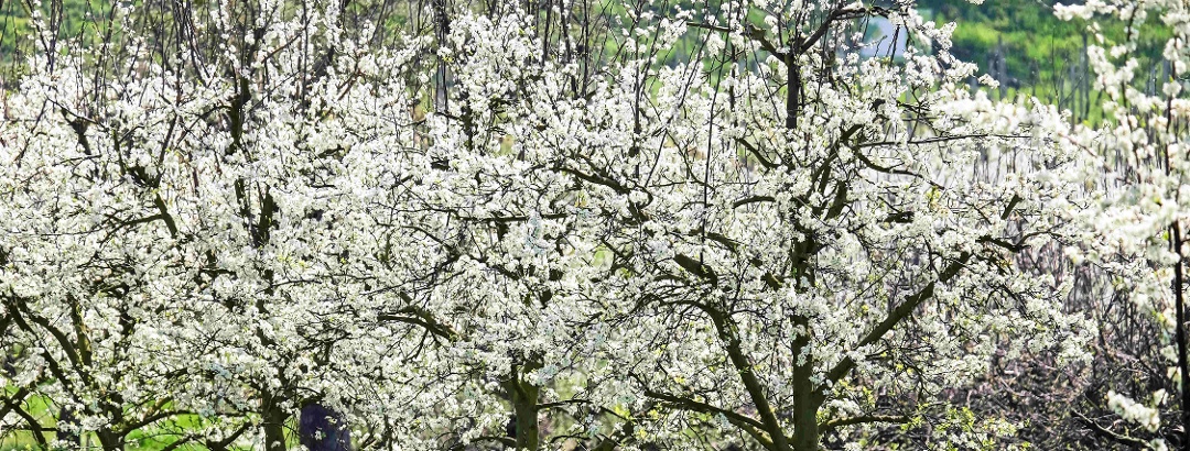
Spring arrives earlier in the Kaiserstuhl than elsewhere in Germany: warm temperatures and plenty of sunshine make the almond, apple and cherry trees blossom. A total of 16 nature reserves in the Kaiserstuhl protect the habitats of numerous animal and plant species that feel at home in the warm climate of the Breisgau. If you go exploring here, you can discover as many as 30 wild orchid species along the way and observe birds such as the hoopoe (German Bird of the Year 2022!) that have become rare elsewhere.

A special feature of the Kaiserstuhl are also the hollow paths, gorge-like paths created by erosion of the loess layer, which served as the only connection between the villages before there were roads and are now protected nature reserves.

The hoopoe is native to the Kaiserstuhl.
Photo: Delyth Williams, CC0, pixabay.com

Hiking in the Kaiserstuhl

Hikers enjoy more than 400 km of signposted routes in the Kaiserstuhl, many of which are themed around topics such as geology, history, nature conservation or water management. Perhaps the most beautiful route is the Kaiserstuhlpfad, a 22-kilometre hiking trail that leads to the most beautiful places in the Kaiserstuhl. In addition, a total of nine nature trails run through the region. The best known of these is the Neunlindenpfad, but the Badbergpfad and the Wiedehopfpfad are also worth a visit.
Kaiserstuhl
Recommended route Kaiserstuhl trail
The Black Forest
Recommended route Black Forest-Kaiserstuhl-Rhine (Black Forest Cross-Route)

Cycling in the Kaiserstuhl

Cyclists go to leisurely pleasure tours or sporty rounds on the 190 km long cycle path network. The paths lead through idyllic wine-growing villages, picturesque terraced vineyards and to unique vantage points. Along the way you can enjoy the regional cuisine. Well-known long-distance cycle paths along the Kaiserstuhl are the Veloroute Rhein, the cycle path "Grüne Straße", the European cycle path Elzach-Villé as well as the Oberrhein-Römer-Radweg and the Badischer Weinradweg.
The Black Forest
Recommended route Upper Rhine Roman Cycle Route through Markgräflerland and Kaiserstuhl
The Black Forest
Recommended route Circular route around the Kaiserstuhl

Trip planning


Weather

10-day forecast

Reviews

  202
Circular route: via Vogtsburg and the Schneckenberg from Achkarren by Thomas
October 05, 2025 · Community
Schöner Rundweg mit überraschend vielen kleinen Pfaden. Beginn alternativ in Oberrotweil
More Show less
Comment
Rheinwald by Heinrich
August 18, 2025 · Community
Nette Tour, aber zum Teil über sehr holprige Wege, auch wenn eine besser fahrbare Alternative neben dran ist.
More Show less
Route done on August 17, 2025
Comment
Gasthaus - Pension zum Bären by Silvi
July 12, 2025 · Community
Leckere, frische und regionale badische Küche, familiengeführter Gasthof. Zimmer sehr einfach ausgestattet, Frühstücksbuffet ausreichend. Gastgeber geben gerne Tipps für Wanderungen und Ausflüge. Touristik Information, Bank und Supermarkt ist auch gleich ums Eck.
More Show less
Photo: Silvi, Community
Comment
Show more Show less

Destinations in the Kaiserstuhl area


THE way to start your next outdoor experience!
Sign up now
App Store
Google Play Store
Huawei App Gallery
  • Our services
    • Features
    • Subscriptions
    • Pro for Search & Rescue
    • Enjoy great benefits and discounts from our partners
    • Vouchers
    • B2B
  • More services
    • Help Center
    • Blog (German only)
    • Newsletter
    • Affiliate Program
    • Contact Us
  • Corporate
    • Discover Outdooractive
    • Outdooractive30
    • Careers
    • Outdooractive Business
Learn more about the apps for Android and iOS
1% for the Planet
Choose a language
English
  • Deutsch
  • italiano
  • français
  • español
  • עברית
  • 中文
  • română
  • português (Portugal)
  • português (Brasil)
  • čeština
  • suomi
  • русский
  • magyar
  • norsk bokmål
  • slovenčina
  • Nederlands
  • 日本語
  • українська
  • हिन्दी
  • Türkçe
  • Ελληνικά
  • Mobile version
  • Terms and conditions
  • Privacy policy
  • Cancellation policy
  • Customer information
  • Terms of payment
  • Map information
  • Legal Disclosure
  • Accessibility