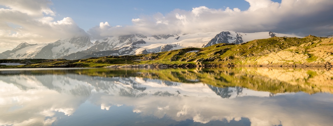
Skip to content
  • Map
  • Route Finder
  • Route Planner
  • Travel Guide
  • Community
Sign up or log in
  • Map
  • Route Finder
  • Route Planner
  • Travel Guide
  • Community
Sign up
  • Places & Accommodation
    • Places to visit
    • Eat & drink
    • Huts
    • Accommodation
    • Ski resorts
    • Crags
  • News & Conditions
    • Current Conditions
    • Weather
    • Webcams
    • Avalanche Report
    • Events
  • Inspiration
    • Collections
    • Offers
    • Travel Stories
    • Publications
  • Community
    • Challenges
    • Groups
  • Settings
  • Help-Center
  • Terms and conditions
  • Privacy policy
  • Legal Disclosure
Travel Guide France Provence-Alpes-Côte-d'Azur Ecrins
more
  • Le Lac Noir sur le Plateau d'Emparis (Parc National des Écrins)
    Le Lac Noir sur le Plateau d'Emparis (Parc National des Écrins) Photo: Nuno Alves, CC BY-SA 4.0 , via Wikimedia Commons

Ecrins

You will remember your vacation in Ecrins for a long time. Find information about fantastic routes, attractions, welcoming mountain huts and Crags in our Travel Guide, where there is also space available for your own content about this protected area! Use the Route Planner to publish your top nature-friendly experiences so that they appear here.

Year of establishment: 1973
Area: 925 km²
Find out more
Digitize the Planet e.V.  Verified partner 
Author of this page
LogoDigitize the Planet e.V.

Activities in Ecrins


Lake and cirque of Arsine at sunrise
hikes
alpine climbing routes
mountain hikes
Crags
long-distance hikes
alpine routes
ski tours trail runs road cycling routes mountain biking trails bike rides

Attractions in Ecrins


Highlights

  • My Map
  • Content
  • Show images Hide images
Features
Maps and trails
Discover
Hiking Trail · Écrins (Pelvoux Group)
(F) Round Puy Aillaud - Lake Puy Aillaud
Toprecommended route Difficulty moderate
Distance 12.5 km
Duration 4:30 h
Ascent 1,150 m
Descent 1,150 m

Nice hike from the hamlet of Puy Aillaud over the viewpoint of the 3 huts (Écrin, Glacier Blanc, Séle) to Lake Puy Aillaud at the foot of the ...

1
from Roland Brömme,   alpenvereinaktiv.com
Hiking Trail · Écrins (Pelvoux Group)
(F) round trip at the valley end of Vallée Freissinières near Dormillouse
Toprecommended route Difficulty moderate
Distance 14.1 km
Duration 6:00 h
Ascent 1,040 m
Descent 1,038 m

Scenic hike along three mountain lakes in the valley end of Vallée Freissinières near Dormillouse at and in the Écrin National Park above the Haut ...

1
from Roland Brömme,   alpenvereinaktiv.com
Mountain Hike · France
Meije crossing
Toprecommended route Difficulty difficult
Distance 12.2 km
Duration 20:00 h
Ascent 1,940 m
Descent 2,692 m

The all-time classic in the Dauphiné: ascent of the Meije via the normal route from the Promontoire hut and further along the ridge to the Doigt de ...

from Thomas Bucher,   alpenvereinaktiv.com
Hiking Trail · Ecrins
Lauzon Lake
Toprecommended route Difficulty easy
Distance 6.5 km
Duration 3:00 h
Ascent 442 m
Descent 442 m

Situated on a plateau at an altitude of 2000 m, the site of Lauzon Lake offers a stunning view of the Gioberney glacial cirque. 

1
from Camille Monchicourt,   Parc National des Ecrins
Hiking Trail · Hautes-Alpes
The balcony of the Oussella and the Quille du Laus
Toprecommended route Difficulty moderate
Distance 10.7 km
Duration 6:00 h
Ascent 898 m
Descent 898 m

A route to discover the Quille du Laus, and the panorama it offers towards Réallon and Serre-Ponçon.

from OTI Serre Ponçon,   OTI Serre-Ponçon
Mountain Hike · Hautes-Alpes
Mountain hike to Lac du Pavé
PremiumPremium content Difficulty difficult
Distance 23.1 km
Duration 11:20 h
Ascent 1,500 m
Descent 1,500 m

The long but very beautiful hike leads to the secluded Lac du Pavé. On a nicely laid out path, we cross a picturesque valley and finally reach the ...

from Tessa Wötzel,   Outdooractive Premium
Long-Distance Hiking · France
HexaTrek: The Great Crossing of France
Toprecommended route Difficulty difficult Multi-day route
Distance 3,041 km
Duration 999:00 h
Ascent 136,300 m
Descent 136,700 m

The HexaTrek is a trail of 3,034 km and 136,000 m of elevation gain connecting 14 of the most beautiful French natural parks and crossing France ...

from HexaTrek La Grande Traversée de France,   HexaTrek : La Grande Traversée de France
Mountain Hike · France
Tête de Vautisse
PremiumPremium content Difficulty difficult
Distance 12.8 km
Duration 6:30 h
Ascent 1,350 m
Descent 1,350 m

Partly pathless but technically easy route on a 3000-meter peak in the Écrins National Park (T4-). Includes scenic ridge hiking.

from Claudia Kurzböck,   Outdooractive Premium
Hiking Trail · Pays des Écrins
The White Glacier
Toprecommended route Difficulty moderate
Distance 9 km
Duration 3:30 h
Ascent 720 m
Descent 720 m

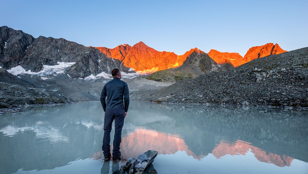
A hike to come in to contact with the white glacier and to approach the mythical summits conquered by the mountaineers of the 19th century. 

Parc National des Ecrins
Hiking Trail · Ecrins
The Arsine Lakes
Toprecommended route Difficulty moderate
Distance 17.6 km
Duration 6:00 h
Ascent 987 m
Descent 987 m

The hamlet of Casset lives according to the changing colours, from the green prairies in the valley to the light blue of the Arsine glacial lakes.

from Camille Monchicourt,   Parc National des Ecrins
Discover more Perimeter: Inventaire National du Patrimoine Naturel
  • My Map
  • Content
  • Show images Hide images
Features
Maps and trails
Discover

Discover the region

huts

Is in the midst of the park

The national park is an unrestricted natural area but subjected to regulations which must be known by all visitors.

Herd protection dogs

In mountain pastures, protection dogs are there to protect the herds from predators (wolves, etc.).

When I hike I adapt my behavior by going around the herd and pausing for the dog to identify me.

Find out more about the actions to adopt with the article Protection dogs: a context and actions to adopt.

Tell us about your meeting by answering this survey.

Trip planning


Weather

10-day forecast

Reviews

  58
Crossing Barre des Écrins (east - west), 4,102 m, AD by Steven
August 10, 2025 · Community
Comment
Rundtour durch den Nationalpark Écrins by Sonja
July 16, 2025 · Community
Route done on July 15, 2025
Photo: System
Comment
GRP® Tour du Vieux Chaillol by Hautes-Alpes
December 21, 2024 · Community
Une boucle incontournable du Champsaur Site officiel du Tour du Vieux Chaillol sur le site du parc national des Ecrins <a href="https://www.grand-tour-ecrins.fr/fr/trek/921156-Tour-du-Vieux-Chaillol" class="oax_externallink" target="_blank" rel="nofollow noopener">https://www.grand-tour-ecrins.fr/fr/trek/921156-Tour-du-Vieux-Chaillol</a>
More Show less
Photo: Hautes-Alpes 05, Community
Comment
Show more Show less

Destinations in Ecrins


Nature regions

  • Geographic region
    France
    Pays des Écrins
App Store
Google Play Store
Huawei App Gallery
  • Our services
    • Features
    • Subscriptions
    • Pro for Search & Rescue
    • Enjoy great benefits and discounts from our partners
    • Vouchers
    • B2B
  • More services
    • Help Center
    • Blog (German only)
    • Newsletter
    • Affiliate Program
    • Contact Us
  • Corporate
    • Discover Outdooractive
    • Outdooractive30
    • Careers
    • Outdooractive Business
Learn more about the apps for Android and iOS
1% for the Planet
Choose a language
English
  • Deutsch
  • italiano
  • français
  • español
  • עברית
  • 中文
  • română
  • português (Portugal)
  • português (Brasil)
  • čeština
  • suomi
  • русский
  • magyar
  • norsk bokmål
  • slovenčina
  • Nederlands
  • 日本語
  • українська
  • हिन्दी
  • Türkçe
  • Ελληνικά
  • Mobile version
  • Terms and conditions
  • Privacy policy
  • Cancellation policy
  • Customer information
  • Terms of payment
  • Map information
  • Legal Disclosure
  • Accessibility