Skip to content
  • Map
  • Route Finder
  • Route Planner
  • Travel Guide
  • Community
Sign up or log in
  • Map
  • Route Finder
  • Route Planner
  • Travel Guide
  • Community
Sign up
  • Places & Accommodation
    • Places to visit
    • Eat & drink
    • Huts
    • Accommodation
    • Ski resorts
    • Crags
  • News & Conditions
    • Current Conditions
    • Weather
    • Webcams
    • Avalanche Report
    • Events
  • Inspiration
    • Collections
    • Offers
    • Travel Stories
    • Publications
  • Community
    • Challenges
    • Groups
  • Settings
  • Help-Center
  • Terms and conditions
  • Privacy policy
  • Legal Disclosure
Travel Guide Brenta Group
more
  • Brenta Dolomites
    Brenta Dolomites Photo: Riccardo Pasciucco, CC BY-SA, Wikimedia Commons
  • In the Brenta
    In the Brenta Photo: Hartmut Wimmer, Outdooractive Premium
  • View of Cima Alto
    View of Cima Alto Photo: Oliver Knorre, DAV Sektion Duisburg
  • Les Dolomites de Brenta Photo: M. Zeni, Archivio Pnab
  • Le pâturage de Ritort et les Dolomites de Brenta Photo: G. Alberti, Archivio Pnab
  • Madonna di Campiglio – Dolomiti di Brenta Photo: Adam Barker, Trentino Marketing

Brenta Group

The Brenta Dolomites are a subsection of the southern Rhaetian Alps and belong to the autonomous province of Trento. With splendid peaks over 3,000 metres, spires and rock towers, magnificent views and interesting hiking trails, they have always been a paradise for hikers and mountaineers. Cycling enthusiasts can enjoy road and off-piste trails. In winter, the area attracts winter sports enthusiasts, while in summer the numerous lakes offer many opportunities to cool off while enjoying some well-deserved relaxation.

Find out more
Outdooractive Editors  Verified partner 
Author of this page

Activities in the Brenta Group


hikes
mountain biking trails
mountain hikes
via ferratas
road cycling routes
bike rides
alpine climbing routes ski tours long-distance hikes bikepacking routes Crags snowshoe walks gravel bike routes winter hikes pilgrim walks trail runs motorcycle routes alpine routes nature trails horse rides runs cross-country ski trails sledding runs horse carriage rides Ski resorts

Attractions in the Brenta Group


Highlights

  • My Map
  • Content
  • Show images Hide images
Features
Maps and trails
Discover
Mountain Biking
Dolomiti di Brenta Bike - Expert
Toprecommended route Difficulty moderate
Distance 184.8 km
Duration 34:05 h
Ascent 7,700 m
Descent 6,738 m

Expert, the tour for the real biker!

from Lorenzo Ventura,   APT Dolomiti di Brenta e Paganella
Hiking Trail · Val di Non
Tour of Lake Tovel
Toprecommended route Difficulty easy
Distance 4.2 km
Duration 1:30 h
Ascent 185 m
Descent 185 m

Nice scenic hike around the famous Lake Tovel, int he heart of the Brenta Dolomites.  

10
from APT Val di Non,   APT Val di Non
Alpine Route · Brenta Group
Dolomiti di Brenta Trek: high altitude circular trekking of 11 stages
Toprecommended route Difficulty difficult
Distance 92.2 km
Duration 40:00 h
Ascent 7,381 m
Descent 7,382 m

The Dolomiti di Brenta Trek embraces the entire Brenta Dolomite Group in a circular route at an average altitude of 2000 meters along 96 km of SAT ...

1
from Azienda per il Turismo Madonna di Campiglio FA,   APT Madonna di Campiglio, Pinzolo, Val Rendena
Via Ferrata · Altopiano della Paganella
Ferrata delle Aquile
Toprecommended route Difficulty D/E difficult Open
Distance 1.5 km
Duration 2:00 h
Ascent 86 m
Descent 264 m

Panoramic, exciting, adrenaline-filled, adventurous, intense. From the top of Paganella, the view stretches over all of Trentino.

11
from Lorenzo Ventura,   APT Dolomiti di Brenta e Paganella
Hiking Trail · Madonna di Campiglio, Pinzolo, Val Rendena
Vallesinella Waterfalls Route
Toprecommended route Difficulty moderate
Distance 11.7 km
Duration 4:00 h
Ascent 310 m
Descent 310 m

Charming route through the woods featuring suspended footbridges and picturesque waterfalls.

8
from Azienda per il Turismo Madonna di Campiglio FA,   APT Madonna di Campiglio, Pinzolo, Val Rendena
Mountain Biking · Brenta Group
Dolomiti di Brenta Bike - Country
Toprecommended route Difficulty moderate
Distance 141 km
Duration 21:40 h
Ascent 3,169 m
Descent 3,081 m

The joy of biking together.  

from Lorenzo Ventura,   APT Dolomiti di Brenta e Paganella
Mountain Hike · Altopiano della Paganella
Hike from Madonna di Campiglio to Molveno, passing through Bocca di Brenta
Toprecommended route Difficulty difficult
Distance 20.5 km
Duration 10:45 h
Ascent 1,470 m
Descent 2,170 m

The crossing of the Brenta Dolomites, from Madonna di Campiglio to Molveno. Attention! During summer 2025 the Pedrotti Refuge is completely ...

1
from Lorenzo Ventura,   APT Dolomiti di Brenta e Paganella
Discover more
  • My Map
  • Content
  • Show images Hide images
Features
Maps and trails
Discover

Where are the Brenta Dolomites?

The austere and wild Brenta Dolomites are located in Trentino and are the westernmost Dolomite group, in a position isolated from the others. More than 42 km long, they are bordered to the north by the Valli di Sole, to the east by the Val di Non and the Paganella plateau, to the south by the Valli Giudicarie and to the west by the Val Rendena.

The famous peaks of the Brenta Dolomites include Cima Tosa (3,173 m), the highest peak of the entire mountain range, Cima Brenta (3,150 m), Crozzon di Brenta (3,122 m), Cima d'Ambiez (3,102 m), Campanile Alto (2,937 m) and Campanile Basso (2,877 m).

The Brenta Dolomites are the most famous peaks of the Brenta Dolomites.

Brenta Dolomites
Photo: Riccardo Pasciucco, CC BY-SA, Wikimedia Commons

A mountain playground in summer...

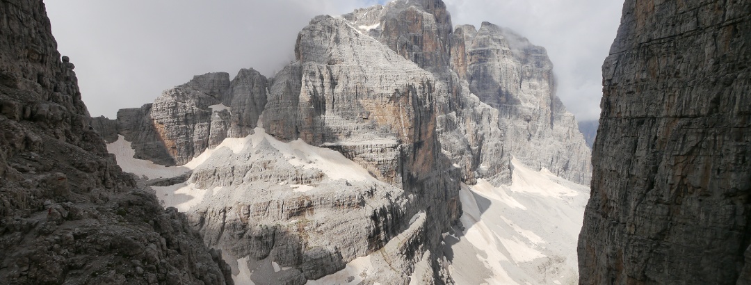
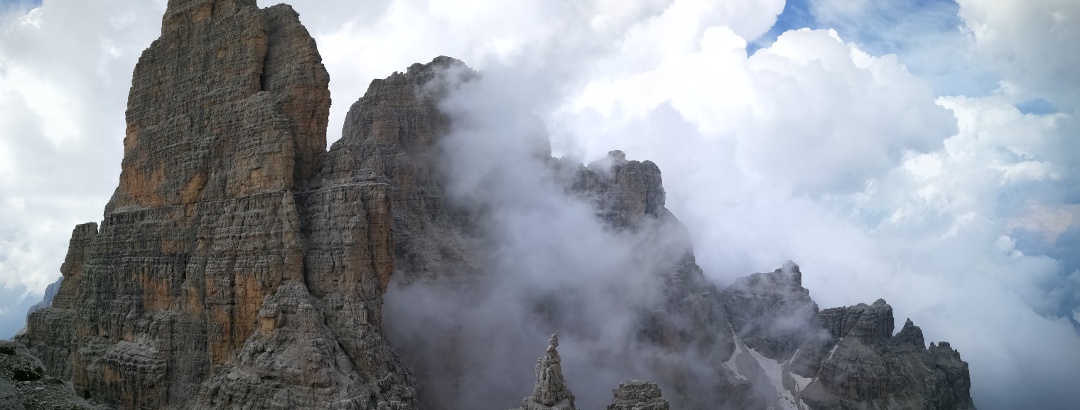
The Brenta Dolomites are characterised by spires, pinnacles, escarpments, dolines and karst cavities, forming a playground for all mountain enthusiasts!

This mountain group offers a vast range of routes suitable for all levels of difficulty and experience. Here you can admire breathtaking landscapes, including rocky peaks, verdant valleys, waterfalls (such as those of Vallesinella), caves, forests and cosy shelters, and discover plant and animal species of all kinds. Particularly worth mentioning are its beautiful Alpine lakes, in particular the Lago di Molveno, the largest in the Brenta dolomites, followed by the fascinating Lake Tovel, famous because, until 1964, its waters were coloured red by algae.

Brenta Group
Travel tip Hikes in the Brenta Group
Brenta Group
Travel tip Mountain hikes in the Brenta Group

Do you fancy a multi-day trek? Then the Dolomiti di Brenta Trek, a ring-route at high altitude, is the right thing for you!  The itinerary is over 90 km long and takes you to the most important refuges in the area, walking at an average altitude of 2,000 metres. An unforgettable experience in almost lunar landscapes.

Alternatively there is the splendid Via delle Normali, a route that alternates between climbing (vie normali) and trekking and links ten of the most beautiful and highest peaks of the Brenta Dolomites, or the Sentiero O. Orsi, a loop in the central Brenta, suitable only for experienced hikers.

  • Alpine Route · Brenta Group
    Dolomiti di Brenta Trek: high altitude circular trekking of 11 stages
  • closed
    Alpine Route · Brenta Group
    The Via delle Normali
  • Alpine Route · Brenta Group
    Tour de la Brenta centrale - Sentier Orsi

The via ferrate of the Brenta Dolomites are among the most beautiful of all the Dolomites and offer breathtaking views of the surrounding peaks and valleys. Unlike other Dolomite ferratas, which retrace routes that date back to the First World War, those in the Brenta Dolomites were created for hiking purposes.

Some of the most famous ferratas are the Via delle Bocchette (divided into Bocchette Alte and Bocchette Centrali), the Ferrata Benini, the Ferrata Castiglioni, the Via Ferrata Brentari and the Ferrata delle Aquile.

Recommended list Via delle Bocchette and Vie ferrate of the Brenta Group
Altopiano della Paganella
Recommended route Ferrata delle Aquile

The spires and high rock faces of the Brenta Dolomites are a real challenge for climbers and offer spectacular views of the surrounding area. The Campanile Basso is certainly the best known climbing spot and has attracted a large number of climbers every year since the first ascent in 1899. Another very beautiful - and extremely scenic - wall is the Cima Paganella.

If you would like to climb in a quieter and less difficult spot, the so-called “Forgotten Cliffs” - which were closed for several decades and reopened to the public in 2017 - are definitely something for you to consider.

  • Alpine Climbing · Brenta Group
    Campanile Basso, Fehrmann route from Rifugio Brentei
  • Alpine Climbing · Brenta Group
    Cima Paganella
  • Alpine Climbing · San Lorenzo Dorsino
    The Forgotten Climbing Wall

In a mountainous area such as the Brenta Dolomites, there is no shortage of opportunities for adrenalin-pumping adventures by mountain bike (also electric). With ups and downs, single trails and forest roads, you can ride through valleys, forests, pastures, apple orchards and tour the area's most interesting mountain huts and alpine pastures.

For longer and more demanding adventures on two wheels, we recommend the Dolomiti di Brenta Bike stage tour - in the Expert and Country variants - or the Round tour of the Brenta Dolomites, ideal for racing bikes, which, in its 136 km length, offers ever-changing beautiful landscapes and many demanding climbs.

Brenta Group
Travel tip Mountain biking in the Brenta Dolomites
Altopiano della Paganella
Recommended route All around the Brenta Dolomites

... and a large ski area in winter

The ski resorts of Madonna di Campiglio, Pinzolo and Andalo - Fai della Paganella make ski enthusiasts happy. They are part of one of the largest ski areas in Europe, the Skirama Dolomiti Adamello Brenta, which boasts more than 380 km of slopes and 150 lift facilities. Snowboarders have several snowparks at their disposal, where they can indulge in jumps and acrobatics (such as the Ursus Snowpark in Madonna di Campiglio).

Do you prefer a more direct contact with nature? Then you can go ski mountaineering or snowshoeing, exploring the snow-covered landscapes away from the beaten tracks, or cross-country skiing, choosing from the numerous trails that wind through woods and valleys. Finally, you can have fun with family or friends tobogganing or bobsleighing on dedicated slopes.

  • Ski tours in the Brenta Group
  • Snowshoe walks in the Brenta Group
  • Cross-country ski trails in the Brenta Group
  • Sledding runs in the Brenta Group

History and culture in the Brenta Dolomites

After exploring the area from a naturalistic point of view, spend some time discovering the villages at the foot of the mountains, rich in history and tradition, and the other sites of cultural interest: the Roman bridge and Napoleonic forts of Molveno, the water-powered sawmills of Molveno and Malè, the charming old town of Pinzolo, the picturesque village of San Lorenzo in Banale, included in the list of Italy's Most Beautiful Villages, the mysterious ghost village of Irone and the archaeological ruins Doss Castel.

  • Museum · Brenta Group
    Venetian sawmill
  • Hiking Trail · Brenta Group
    Pinzolo - Historic Centre

In the area of the Brenta Dolomites, there are also a large number of splendid castles: Castel Cles, Castel Belasi, Castel Valer, Castel Nanno and Castel Belfort in Val di Non and Castel Stenico in Valli Giudicarie.

  • Belasi Castle
  • Nanno Castle

Discover the region

Accommodation
places to eat and drink
Dog-friendly hiking
huts
Accessibility
Webcams
Show more Show less

Authentic Experiences and Guided Tours

  • from €120.00
    Summer Sporting Fun · Altopiano della Paganella
    Via Ferrata delle Aquile
Show all offers in the Brenta Group

Trip planning


Weather

10-day forecast

Current Conditions

Map / Closure of the paths around Cima Falkner
since July 29, 2025 · Brenta Group
Closure of the paths around Cima Falkner

Webcams

  • Webcams · Madonna di Campiglio, Pinzolo, Val Rendena
    Tre Ville: Lago Montagnoli
  • Webcams · Altopiano della Paganella
    Vallelaghi: Andalo - Paganella
  • Webcams · Garda Trentino
    Vallelaghi › North
  • Webcams · Altopiano della Paganella
    Molveno: Pradel
  • Webcams · Madonna di Campiglio, Pinzolo, Val Rendena
    Giustino: Pinzolo - Doss Del Sabion
  • Webcams · Altopiano della Paganella
    Andalo: Dosson
  • Webcams · Altopiano della Paganella
    Andalo: Teresat
  • Webcams · Altopiano della Paganella
    Vallelaghi: Andalo - Paganella
  • Webcams · Madonna di Campiglio, Pinzolo, Val Rendena
    Tre Ville: Madonna die Campiglio - Groste
  • Webcams · Altopiano della Paganella
    Fai della Paganella: Andalo - Meriz
  • Webcams · Altopiano della Paganella
    Vallelaghi
  • Webcams · Madonna di Campiglio, Pinzolo, Val Rendena
    Tre Ville: Madonna di Campiglio
Show all Webcams in the Brenta Group

Reviews

  1,034
Breve anello in mountain bike da Cles passando per Tassullo, Taio, Segno il 26 ottobre 2025 by Massimiliano
October 26, 2025 · Community
Foliage
More Show less
Comment
Via ferrata della Aquile -Paganela by Dominic
October 12, 2025 · Community
<p dir="ltr">Beautiful and stunning as the tour is discribed as. Simpel to reach, nice view and not as challenging as other things. The desend from the station at top can be directly be made over the ski piste.</p>
More Show less
Route done on October 11, 2025
Photo: Dominic Zani, Community
Comment
Croz dell' Altissimo by Dominic
October 12, 2025 · Community
<p dir="ltr">The route is quiet stunning. The view is great and the trail up is awesome.</p> <p dir="ltr">But the trail downhill from the picco lasteri onwards is really steap and difficult. I dont recommend this trail for people, who havent any&nbsp; experience with complicated and challenging steap desends. Maybe just go to the peak and then go back the same way down as up. Also we had much longer than the route is timed on (slow-medium speed up, medium speed down = ca. 6h)</p> <p dir="ltr">All in all a great route with superb view at the mountains.</p>
More Show less
Route done on October 12, 2025
Photo: Dominic Zani, Community
Comment
Show more Show less
THE way to start your next outdoor experience!
Sign up now
App Store
Google Play Store
Huawei App Gallery
  • Our services
    • Features
    • Subscriptions
    • Pro for Search & Rescue
    • Enjoy great benefits and discounts from our partners
    • Vouchers
    • B2B
  • More services
    • Help Center
    • Blog (German only)
    • Newsletter
    • Affiliate Program
    • Contact Us
  • Corporate
    • Discover Outdooractive
    • Outdooractive30
    • Careers
    • Outdooractive Business
Learn more about the apps for Android and iOS
1% for the Planet
Choose a language
English
  • Deutsch
  • italiano
  • français
  • español
  • עברית
  • 中文
  • română
  • português (Portugal)
  • português (Brasil)
  • čeština
  • suomi
  • русский
  • magyar
  • norsk bokmål
  • slovenčina
  • Nederlands
  • 日本語
  • українська
  • हिन्दी
  • Türkçe
  • Ελληνικά
  • Mobile version
  • Terms and conditions
  • Privacy policy
  • Cancellation policy
  • Customer information
  • Terms of payment
  • Map information
  • Legal Disclosure
  • Accessibility