Skip to content
  • Map
  • Route Finder
  • Route Planner
  • Travel Guide
  • Community
Sign up or log in
  • Map
  • Route Finder
  • Route Planner
  • Travel Guide
  • Community
Sign up
  • Places & Accommodation
    • Places to visit
    • Eat & drink
    • Huts
    • Accommodation
    • Ski resorts
    • Crags
  • News & Conditions
    • Current Conditions
    • Weather
    • Webcams
    • Avalanche Report
    • Events
  • Inspiration
    • Collections
    • Offers
    • Travel Stories
    • Publications
  • Community
    • Challenges
    • Groups
  • Settings
  • Help-Center
  • Terms and conditions
  • Privacy policy
  • Legal Disclosure
Travel Guide Karwendel
more
  • Blick aufs Karwendelgebirge
    Blick aufs Karwendelgebirge Photo: Wolfilser, Adobe Stock

Karwendel

The Karwendel region in Tyrol and Bavaria captivates with its flowering mountain meadows and rugged peaks, rushing mountain streams and fresh mountain air. In the past, Romans, merchants and pilgrims came to the region, but today it is mainly hikers, cyclists and families who enjoy the beautiful landscape. From its source in the Karwendel Mountains, the turquoise Isar River meanders through a sunny high valley to Bavaria. Numerous lakes offer an ideal excursion destination in hot temperatures.
Find out more
Outdooractive Editors  Verified partner 
Author of this page
LogoOutdooractive Editors

Activities in the Karwendel region


Wandern im Karwendel
hikes
mountain hikes
mountain biking trails
bike rides
road cycling routes
long-distance hikes
trail runs ski tours via ferratas bikepacking routes snowshoe walks winter hikes Crags motorcycle routes pilgrim walks alpine routes scenic routes gravel bike routes alpine climbing routes runs cross-country ski trails nature trails sledding runs caravan trips kayak trips Ski resorts backcountry skiing routes

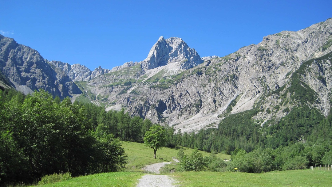
Attractions in the Karwendel region


Highlights

  • My Map
  • Content
  • Show images Hide images
Features
Maps and trails
Discover
Long-Distance Hiking · Tux Alps
Inntal High Trail
Toprecommended route Difficulty T4 difficult Multi-day route
Distance 74.3 km
Duration 29:45 h
Ascent 4,758 m
Descent 5,228 m

The "Inntal High Trail" runs six days along the 2000m altitude line eastwards above the Tyrolean Inn Valley from Innsbruck-Igls through the Tux ...

8
from Stefanos Rauchegger,   alpenvereinaktiv.com
Mountain Biking · Ranggen
From Innsbruck via Ranggen to the Rangger Köpfl
Toprecommended route Difficulty S0 difficult
Distance 64.5 km
Duration 7:15 h
Ascent 1,475 m
Descent 1,475 m

A beautiful mountain bike tour leads from Innsbruck to the west up to the Rangger Köpfl at 1939 m. The ride along meadows through various villages ...

1
from Josef Essl,   alpenvereinaktiv.com
Mountain Hike · Karwendel
Östliche Karwendelspitze 2537m Überschreitung
Toprecommended route Difficulty T4I difficult
Distance 30.2 km
Duration 9:00 h
Ascent 1,800 m
Descent 1,800 m

Aussichtsreicher und nicht allzu schwerer aber dennoch nicht zu unterschätzender Gipfel im Nahbereich des Karwendelhauses.

1
from Wolfgang Lauschensky,   alpenvereinaktiv.com
Mountain Hike · Karwendel
Hohe Fürleg - crossing
Toprecommended route Difficulty difficult
Distance 9.3 km
Duration 7:30 h
Ascent 1,171 m
Descent 1,878 m

Long, in the second part lonely crossing of the easternmost Karwendel peaks of the Gleiersch-Halltal chain: Hundskopf - Tratenspitze - ...

3
from Michael Larcher,   alpenvereinaktiv.com
Mountain Hike · Karwendel
from Kranebitten over the Hechenberg East Summit to the New Magdeburger Hut
Toprecommended route Difficulty T4 difficult closed
Distance 4.7 km
Duration 4:30 h
Ascent 1,100 m
Descent 344 m

The most challenging and difficult ascent to the New Magdeburger Hut should only be used for ascending. 

1
from Beda Weidemann,   alpenvereinaktiv.com
Mountain Hike · Karwendel
Kleiner Lafatscher from the Hallerangerhaus
Toprecommended route Difficulty T4II- difficult
Distance 6.6 km
Duration 4:00 h
Ascent 900 m
Descent 900 m

The scarcely frequented summit is climbed almost pathlessly from the Lafatscherjoch over the brittle-rocky southeast ridge in easy climbing up to ...

1
from Wolfgang Lauschensky,   alpenvereinaktiv.com
Mountain Hike · Karwendel
Seefelder Spitze and Reither Spitze
Toprecommended route Difficulty T4 moderate
Distance 16.1 km
Duration 8:00 h
Ascent 1,500 m
Descent 1,500 m

Well frequented and well-developed summit paths on two viewpoints at Seefeld.

1
from Wolfgang Lauschensky,   alpenvereinaktiv.com
Mountain Hike · Karwendel
Round tour from Mittenwald via Rehbergalm and Wörnerkopf to the Hochlandhütte
Toprecommended route Difficulty difficult
Distance 13.3 km
Duration 7:30 h
Ascent 1,111 m
Descent 1,111 m

Varied, shady and easy circular tour with little traffic in the first part. Then more challenging from Wörnerkopf onwards. Always great views in ...

1
from Ulrich Koppold,   alpenvereinaktiv.com
Mountain Hike · Karwendel
Sonnjoch (2459m) East-West crossing
Toprecommended route Difficulty moderate
Distance 10.2 km
Duration 6:00 h
Ascent 1,360 m
Descent 1,360 m

Great demanding crossing of the Sonnjoch. Changing views of the Karwendel and the Achensee, as well as an interesting route, guarantee a great ...

3
from Rafael Reder,   alpenvereinaktiv.com
Mountain Biking · Karwendel
Vomper Loch - Ganalm - Walder Alm - Hinterhornalm
Toprecommended route Difficulty moderate
Distance 23.2 km
Duration 4:00 h
Ascent 847 m
Descent 847 m

Extensive circular route with breathtaking deep views and a rapid descent.

4
from Cathleen Peer,   alpenvereinaktiv.com
Discover more
  • My Map
  • Content
  • Show images Hide images
Features
Maps and trails
Discover

Discover the region

Accommodation
places to eat and drink
huts
offers
Dog-friendly hiking
Accessibility
Show more Show less

Location and extent of the Karwendel

Most of the Karwendel is located on Austrian territory in Tyrol, but part of the mountain range also extends into the German state of Bavaria. Divided into four large mountain ranges leading from west to east, numerous side chains and a vast promontory in the north, the Karwendel is a mountain group of the Northern Limestone Alps. Over 45 km long and 30 km wide, the mountain range has 125 peaks of two thousand meters, of which the Birkkarspitze is the highest at 2749 m. The Karwendel is surrounded by the villages of Seefeld in Tyrol and Mittenwald in the west, Pertisau in the east and Innsbruck in the south, while Hinterriß is the only permanent settlement within the mountains.
The Gamsjoch group from the Sonnjoch west flank, on the left the Laliderer Wand with Kaltwasserkarspitze and Birkkarspitze, on the right the Falken Group
Photo: Tirolerbergwelten, CC BY-SA, Wikimedia Commons

Karwendel Nature Park

The Karwendel Nature Park is the largest nature park in Austria and consists of three nature reserves, two rest areas and six landscape protection areas. Directly adjacent to it, the protection of the Karwendelgebirge nature is continued by the German Karwendel nature reserve and Karwendel foothills. As one of the last large areas in the Alps not yet completely covered by lifts, there is still a lot of wild nature to be found here. In the mountain center, there is little civilization, so the forest and the Isar river still develop naturally here. A special feature of the Karwendel is the large population of golden eagles. When visiting the nature reserves, you should pay attention to the prohibitions in force.
The Vorkarwendel from the Seebergspitze
Photo: Tirolerbergwelten, CC BY-SA, Wikimedia Commons

Hiking in the Karwendel

Hikers and mountaineers love to come to the Karwendel. While there are no gondolas and lifts in the interior of the mountains, there are some on the edges, which are uphill from the villages. There are 25 serviced huts in the Karwendel, as well as self-catering huts and bivouac boxes. Those who take a longer tour, such as the Red Route of the Via Alpina or the Munich-Venice Dream Trail, can stay overnight in these when crossing the mountains. Popular shorter routes lead to the Mittenwalder Hütte, over the Sulzeklamm suspension bridge to the Brunnsteinhütte or to the top station of the Karwendel cable car.
  • closed
    Long-Distance Hiking · München-Ingolstadt
    Traumpfad München Venedig (komplett)
  • Hiking Trail · Karwendel
    Access to Brunnstein Hut from Mittenwald/ hut parking
  • Mountain Hike · Karwendel
    Approach to the Brunnstein Hut from the Karwendelbahn mountain station

Challenging hikes in the Karwendel mountains

Mountain climbers venture farther into the mountains. While only a few peaks of the two mighty central mountain ranges are accessible by good pathways, most other peaks can be reached from the south without major climbing difficulties. However, the climbs through craggy, mountain pine or scree fields are sometimes pathless and the rock is often fragile. The Karwendel Altitude Trail is ideal for those looking for adventure.
  • Mountain Hike · Karwendel
    Sonntagskarspitze (2525 m) from the Pfeishütte
  • Mountain Hike · Karwendel
    Approach from the Hafelekar mountain station to the Pfeishütte
  • Long-Distance Hiking · Karwendel
    Karwendel Höhenweg
  • Mountain Hike · Karwendel
    Hohe Fürleg (2570 m) from the Hinterhornalm
  • Mountain Hike · Silberregion Karwendel
    Approach to Lamsenjoch Hut from the Eng
  • Mountain Hike · Karwendel
    Sonnjoch (2459m) East-West crossing

Nature excursion destinations in the Karwendel

Beautiful excursion destinations include the Gleirschklamm Gorge (with an untamed wild river), the Hafelekar (the window into the Karwendel) and the Halltal Valley as a valley with history and wildly romantic nature. Routes to the Hochplatte, a gentle peak with flowering meadow slopes above Lake Achensee, to the source of the Isar or to the Mondscheinspitze, the residential area of the ibex, are also worthwhile. Through the Wolfsklamm Gorge and dense forest, you reach a pilgrimage church enthroned on rocks and the Lalidererwände are probably the most famous northern walls of the Limestone Alps, whose colossal grey rock faces tower above the green alpine meadows.
  • Hiking Trail · Region Innsbruck
    From the Seegrube over the Gleirschspitze to the Hafelekar
  • Hiking Trail · Hall-Wattens
    Through the Halltal to the gem Issanger
  • Mountain Hike · Hall-Wattens
    Through the Halltal to the Hallerangeralm and to the Hallerangerhaus
  • Mountain Hike · Karwendel
    Hochplatte 1813m
  • Mountain Biking · Karwendel
    Kastenalm from Scharnitz via the Isar source
  • Mountain Hike · Silberregion Karwendel
    Bettlerkarspitze und Mondscheinspitze
  • Mountain Hike · Achensee in Tirol
    Mondscheinspitze
  • Hiking Trail · Karwendel
    Through Wolfsklamm to St. Georgenberg: gentle route
  • Long-Distance Hiking · Karwendel
    To Mahnkopf – between Lalidererwände and Ahornboden (two-day tour)

Authentic Experiences and Guided Tours

  • from €10.00
    Expeditions · Hall-Wattens
    Town tour&mining museum in Hall in Tirol
  • from €8.00
    Organized hiking · Hall-Wattens
    A guided walk through the centuries
  • from €6.00
    Museum · Hall-Wattens
    In the beginning there was salt
  • from €6.00
    Guided Tour · Hall-Wattens
    Guided tour of Mining Museum, Bergbaumuseum Hall in Tirol, North Tyrol
  • from €7.20
    Guided Tour · Hall-Wattens
    Guided Tour: Hall in Tirol
  • from €14.50
    Guided Tour · Silberregion Karwendel
    Schloss Tratzberg: Entry Ticket + Guided Tour
  • from €13.50
    Guided Tour · Silberregion Karwendel
    Tratzberg Castle: Entrance + Virtual Reality Tour
Show all offers in the Karwendel region

Trip planning


Weather

10-day forecast

Climate

__data.scaleLeft || ''__ __data.scaleRight || ''__
Day max. | Day min. Average number of hours of sun per day

Webcams

  • Webcams · Achensee in Tirol
    Gemeinde Achenkirch: Achenkirch - Achensee
  • Webcams · Achensee in Tirol
    Gemeinde Eben am Achensee: Pertisau - Achensee
  • Webcams · Achensee in Tirol
    Pertisau: Golfclub Achensee
  • Webcams · Achensee in Tirol
    Pertisau: Feilkopf - Achensee - Karwendel
  • Webcams · Region Innsbruck
    Hotting: Innsbruck Airport
  • Webcams · Region Innsbruck
    Innsbruck: Patscherkofel
  • Webcams · Achensee in Tirol
    Gemeinde Achenkirch: Achenkirch - Österreich
  • Webcams · Region Seefeld
    Gemeinde Seefeld in Tirol: Seefeld - Seefelder Joch
  • Webcams · Silberregion Karwendel
    Stadt Schwaz: Schwaz - Silberregion Karwendel
  • Webcams · Hall-Wattens
    Stadt Hall in Tirol: Hall in
  • Webcams · Region Seefeld
    Gemeinde Reith bei Seefeld: Seefeld - Reith bei Seefeld
  • Webcams · Region Seefeld
    Gemeinde Scharnitz: Seefeld - Scharnitz
Show all Webcams in the Karwendel region

Reviews

  2,000
Lenggries Walking by Alireza
Yesterday · Community
Comment
Karwendelrunde am 4. Oktober 2022 by Constanze
October 19, 2025 · Community
<p dir="ltr">Eine sehr anstrengende aber landschaftlich einfach fantastische Tour. Besonders bei Herbstfärbung!</p>
More Show less
Photo: Constanze D, Community
Comment
Montscheinspitze - a vigorous Karwendel route by Matze
October 18, 2025 · Community
Comment
Show more Show less

Destinations in the Karwendel region


Nature regions

  • Nature park
    Nature park · Tyrol
    Naturpark Karwendel
THE way to start your next outdoor experience!
Sign up now
App Store
Google Play Store
Huawei App Gallery
  • Our services
    • Features
    • Subscriptions
    • Pro for Search & Rescue
    • Enjoy great benefits and discounts from our partners
    • Vouchers
    • B2B
  • More services
    • Help Center
    • Blog (German only)
    • Newsletter
    • Affiliate Program
    • Contact Us
  • Corporate
    • Discover Outdooractive
    • Outdooractive30
    • Careers
    • Outdooractive Business
Learn more about the apps for Android and iOS
1% for the Planet
Choose a language
English
  • Deutsch
  • italiano
  • français
  • español
  • עברית
  • 中文
  • română
  • português (Portugal)
  • português (Brasil)
  • čeština
  • suomi
  • русский
  • magyar
  • norsk bokmål
  • slovenčina
  • Nederlands
  • 日本語
  • українська
  • हिन्दी
  • Türkçe
  • Ελληνικά
  • Mobile version
  • Terms and conditions
  • Privacy policy
  • Cancellation policy
  • Customer information
  • Terms of payment
  • Map information
  • Legal Disclosure
  • Accessibility