Haute-Maurienne-Vanoise
Did you ever ride a mountain bike at the foot of a glacier? Ever gravelled your way to the top of a mountain under the whistle of a marmot? Ever climbed the Col de l'Iseran, Europe's highest road pass? No? Then it's time to discover Haute Maurienne Vanoise on two wheels!
Haute Maurienne Vanoise is a high-altitude valley between the Vanoise National Park and Italy. Easily accessible by motorway or TGV, this territory offers an unspoiled, alpine playground for lovers of mountain biking, hiking and all outdoor sports.
Activities in Haute Maurienne Vanoise
Attractions in Haute Maurienne Vanoise
Highlights
Hike in the heart of the Vanoise National Park with open views of the Haute Maurienne valley towards Modane, views of the Dent Parrachée and the ...
Above Bonneval sur arc, the Evettes glaciers is one of the most extraordinary one in Savoy Mont ...
The natural site of Mont-Thabor lays between 1750 m and 3178m altitude over 4 806 hectares and ...
This is an easy, mostly singletrack itinerary presenting no real technical difficulty.
From 1861, the priorities of the Kingdom of Italy were unity and territorial defense. It therefore ...
After traversing the Haute Maurienne and going up some steep switchbacks lined with kilometre markers, you emerge at the Col du Mont Cenis beside ...
Cooled by the breeze of the Petit Mont-Cenis pass, this route takes you on an adventure at more than 2,100 metres above sea level, under the ...
Haute Maurienne Vanoise, the great outdoors
The Haute Maurienne is located in the Northern Alps and is one of the three main valleys of the Savoie region. From Modane to Bonneval sur Arc, it borders the Vanoise National Park to the north and the peaks of the Italian Piedmont to the south.
The villages and hamlets inhabited all year round, the large protected areas, the generous nature and the numerous activities make this area a popular travel destination.
Here the mountains are omnipresent and can be explored on foot, by bike or on skis. Hiking, mountain biking, unusual places, unspoiled villages, old fortresses clinging to the rocks and chapels with extravagant baroque decorations, culinary specialities... You will appreciate the Haute Maurienne for its extravagant natural beauty!
The Arc is the river that runs through the entire valley and flows into the Isère. According to legend, the word 'Maurienne' comes from the Piedmontese dialect 'Mo riu', which means 'bad stream'. In fact, it is a capricious river that caused some devastating floods in the past, such as in Modane in 1957. Today the Arc, channelled by several hydroelectric dams, is a calm river of clear beauty, ideal for trout fishing.
Another legend says that the word 'Maurienne' comes from the fact that the valley was invaded by the Moors in the 10th century. Incidentally, on the Valfréjus side there is the Pointe des Sarrasins, the Col and the Crête des Sarrasins, which are almost 3,000 metres high.
A MOUNTAIN BIKE / E-MOUNTAIN BIKE DESTINATION
Mountain biking in the wild
In Haute Maurienne Vanoise, you're in for a real treat with mountain bike trails in the heart of a mountain that's still wild. On some routes, you'll come across more marmots than humans! In this very cross-country territory, you can ride at the foot of glaciers or link up singles in the middle of larches.
In summer, the ski lifts take you effortlessly to the top of some of the courses for a series of enduro singles, particularly in the resorts of Aussois, Val Cenis and La Norma.
A playground for all the family and all tastes, Haute Maurienne Vanoise also boasts a number of fun mountain biking areas, including Chantelouve, a unique area in France with green, blue, red and black singles that criss-cross and intertwine to suit your current level or fitness.
5 must-try Cross Country routes in Haute Maurienne Vanoise:
Mythical mountain passes and gravel in the Alps
Explore the Haute Maurienne Vanoise at your own pace and on your favorite machine: mountain bike, gravel, road, the choice is yours.
Gravel up to 3000 meters!
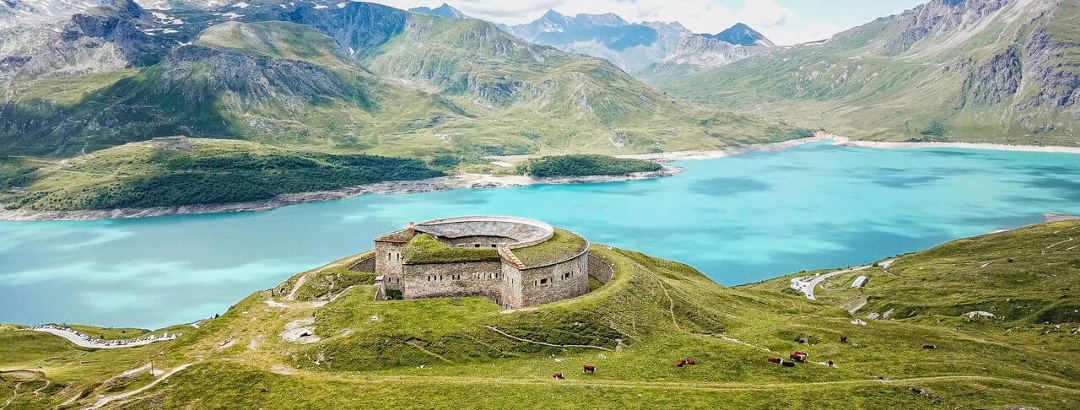
In Haute Maurienne Vanoise, gravel is practiced in "high mountain" mode. On the border between France and Italy, the area is crisscrossed with mountain pasture roads and former military tracks that are perfect for this sport. For example, you can climb up to the Malamot fort, at almost 3,000 meters. On arrival: an ancient fortress with a Machu Picchu appearance, a breathtaking view of the French and Italian Alps and ibex, which are often in this area in summer.
Iseran and Galibier on the road
You can also try your hand at some of the greatest mountain passes, with the Iseran, Europe's highest road pass, and the legendary Galibier, Glandon and Croix de Fer just a few pedal strokes away. The Maurienne valley boasts an exceptional density of legendary mountain passes. It's no coincidence that the Tour de France passes through here almost every year!
And until early July, if you climb the Iseran, you can pass through walls of snow... take a selfie!
The road to happiness
Travel through Haute Maurienne Vanoise from Modane station to the hamlet of l'Ecot, at the very end of the valley, along the Chemin du Petit Bonheur.
There are 50km of valley trails to be explored on foot, by bike or on horseback, passing through typical villages, enjoying the great outdoors and discovering some amazing facilities along the way: a forest of swings, giant picnic tables, solariums and wind generators.
As you make your way along the route, you'll gain in altitude and follow the evolution of nature, from the forests to the mountain pastures at over 2000m, via the meadows around the villages. The route is always surrounded by peaks topping out at over 3,000m.
But why the name?
The Chemin du Petit Bonheur is an ancestral trail that runs from village to village throughout Haute Maurienne Vanoise. The origin of its name has been lost, but some locals claim that it was named by the boys from Val Cenis, who used this forest path to discreetly meet the girls in the next village.
Untouched nature and vast landscapes!
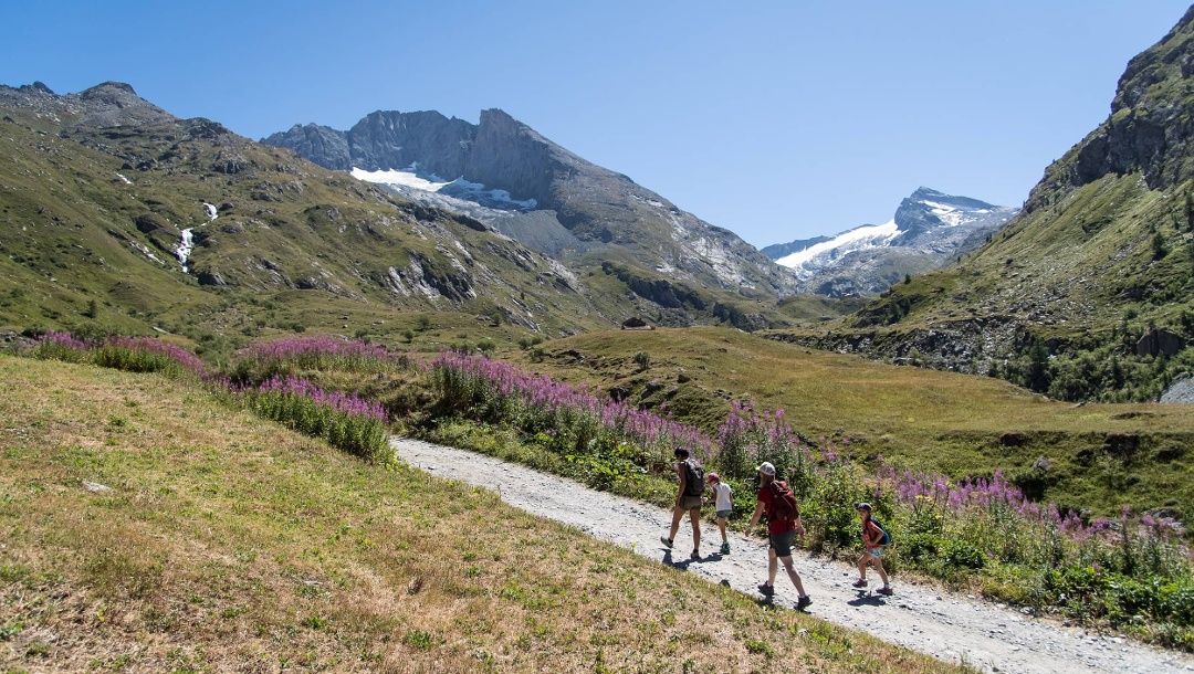
Hiking at over 3000 meters!
The Vanoise National Park, which has protected mountain flora and fauna since 1963, covers a large part of Haute Maurienne Vanoise. Crisscrossed by the GR5 and other hiking trails, the park offers a wealth of opportunities to discover wide-open spaces steeped in silence, serenity and beauty, all conducive to rejuvenation.
Did you know that our valley is home to over a hundred peaks over 3,000 meters high? Would you be tempted by one of them? The 3,000-meter mark is easy to reach from 1,500, 1,800 or 2,000 meters, and there's no need for crampons, ice axes or ropes!
Say hello to the marmots in the heart of the Vanoise!
The Vanoise National Park, which has protected mountain flora and fauna since 1963, covers a large part of Haute Maurienne Vanoise. Crisscrossed by the GR5 and other hiking trails, the park offers a wealth of opportunities to discover wide-open spaces steeped in silence, serenity and beauty, ideal for rejuvenation.
While the Vanoise National Park has made it possible to preserve the ibex, an animal emblematic of the Alps, and to once again see golden eagles and bearded vultures soaring in the skies, it is the marmots that are the real mascots of the Park. In the Orgère valley, at the bottom of Aussois, on Mont Cenis or between Bessans and Bonneval sur Arc, they're everywhere! You'll hear them whistling as you pass - it's up to you to spot them!
Water, the best remedy for heat!
Certes, il fait de plus en plus chaud mais nous, nous avons la chance de vivre en altitude, au pied des glaciers. Une fraîcheur qui nous permet de bien dormir la nuit, des cascades qui nous servent de brumisateurs naturels, des ruisseaux dans lesquels les enfants peuvent jouer, des lacs d’altitude où se reflètent les sommets enneigés et où l’on trempera ses pieds après une belle randonnée... Que des solutions anti-canicule !
History and cuisine: the treasure trove of cultural heritage
As a border area with Italy, the Haute Maurienne valley has been a transit area for centuries. From Hannibal's army and his elephants to the peddlers and traders, from Napoleon to Montaigne, the passes of the Haute Maurienne have been busy at all times. Numerous military forts were built to defend the country, real sentinels of sometimes imposing size like the Forts de l'Esseillon.
In the high valleys of the Alps, life was once hard and barren, but the faith of the mountain dwellers was alive. Proof of this lie in the oratories and chapels that can be discovered even at high altitude, and the churches of our villages in dazzling Baroque style. A cultural heritage of great richness that is definitely worth discovering!
Mountain farming makes it possible to enjoy culinary treasures such as Beaufort AOP, Termignon blue cheese, the delicious Bessans ham and local beers, which can be tasted directly at the brewery or in the mountain huts.
Discover the region
Trip planning
Weather
Getting there
Reviews
Destinations in Haute Maurienne Vanoise
Localization