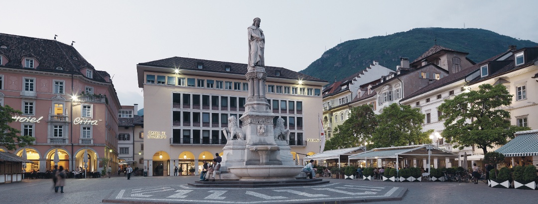
Skip to content
  • Map
  • Route Finder
  • Route Planner
  • Travel Guide
  • Community
Sign up or log in
  • Map
  • Route Finder
  • Route Planner
  • Travel Guide
  • Community
Sign up
  • Places & Accommodation
    • Places to visit
    • Eat & drink
    • Huts
    • Accommodation
    • Ski resorts
    • Crags
  • News & Conditions
    • Current Conditions
    • Weather
    • Webcams
    • Avalanche Report
    • Events
  • Inspiration
    • Collections
    • Offers
    • Travel Stories
    • Publications
  • Community
    • Challenges
    • Groups
  • Settings
  • Help-Center
  • Terms and conditions
  • Privacy policy
  • Legal Disclosure
Travel Guide Italy South Tyrol Bolzano and environs Bolzano
more
  • Waltherplatz in the center of Bolzano
    Waltherplatz in the center of Bolzano Photo: Tourismusverband Südtirols Süden, Tourismusverband Südtirols Süden

Bolzano

You will remember your vacation in Bolzano for a long time. Find information about fantastic routes, attractions, typical accommodation, places to eat and drink, great offers, Crags, Webcams, Great places to visit with the family, Accessibility and Dog-friendly hiking in our Travel Guide, where there is also space available for your own content! Use the Route Planner to publish your best experiences so that they appear here.
Find out more
Outdooractive Editors  Verified partner 
Author of this page
LogoOutdooractive Editors

Activities in Bolzano


road cycling routes
hikes
bike rides
mountain biking trails
bikepacking routes
long-distance hikes
trail runs pilgrim walks motorcycle routes city walks scenic routes runs Crags nature trails alpine climbing routes gravel bike routes caravan trips

Attractions in Bolzano


Discover our Top Partner

  • Dips - French Tacos & Salads
  • Stadt Brasserie Città
  • Stadt Hotel Bar Città
  • VILLAREJA Batzen - Boutique comofort. Designed with care
  • VILLAREJA Wanger - Penthouse Suite
  • Metzgerei Stampfl
 Sponsored

Highlights

  • My Map
  • Content
  • Show images Hide images
Features
Maps and trails
Discover
Hiking Trail · Sarntal Alps
From Bolzano to Oberbozen
Toprecommended route Difficulty T1 moderate
Distance 8.4 km
Duration 3:30 h
Ascent 917 m
Descent 1 m

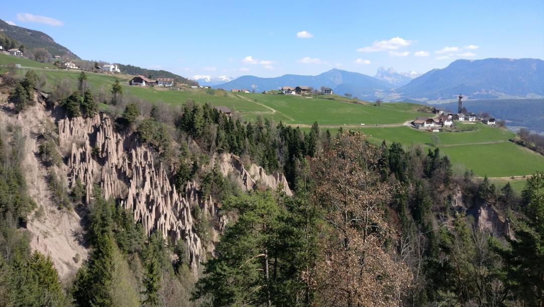
Scenic hike to the Ritten high plateau with a visit to the Hörtenberger Cross

4
from Eduard Gruber,   alpenvereinaktiv.com
Hiking Trail · Leifers
Leiferer Höhenweg
Toprecommended route Difficulty moderate
Distance 10.9 km
Duration 4:09 h
Ascent 720 m
Descent 745 m

Scenic route from Leifers to St. Jakob on a section of the Leiferer Höhenweg. The return trip can be done on foot or by public bus.

2
from Stefan Steinegger,   alpenvereinaktiv.com
Bike Riding · Fiemme Mountains
Cycle route from Reschen Pass to Lake Garda (overview)
Toprecommended route Difficulty moderate Multi-day route
Distance 249.7 km
Duration 18:45 h
Ascent 2,312 m
Descent 3,570 m

Beautiful, scenic cycle route that runs about 90% flat or downhill along the Etsch to Trento (Trient). From here, it goes up a few meters over the ...

1
from Juergen Hilgenberg,   alpenvereinaktiv.com
Bikepacking
Adige cycle route along the Via Claudia Augusta – cultural experience between gardens and architecture
Toprecommended route Difficulty moderate Multi-day route
Distance 148.5 km
Duration 7:45 h
Ascent 380 m
Descent 1,625 m

Relaxed cycling not only along the Adige, but also following Roman footsteps – that is what the Adige cycle route along the Via Claudia Augusta ...

1
from Monika Heindl,   alpenvereinaktiv.com
Hiking Trail · Bolzano and environs
Over the Titschen near Bolzano
PremiumPremium content Difficulty moderate
Distance 8.8 km
Duration 3:30 h
Ascent 509 m
Descent 509 m

Cozy circular hike with the best views over Bolzano and the South Tyrolean mountain scenery

1
from Hartmut Wimmer,   Outdooractive Premium
Bike Riding · Nonsberg Group
From Reschen Pass to Lake Garda, stage 3
Toprecommended route Difficulty moderate Stage 3
Distance 65.9 km
Duration 4:30 h
Ascent 71 m
Descent 125 m

The cycle path leads from Bolzano constantly along the Adige River to Trento.

1
from Juergen Hilgenberg,   alpenvereinaktiv.com
Hiking Trail · Bolzano and environs
Via the Oswald Promenade to Runkelstein Castle
PremiumPremium content Difficulty easy
Distance 8.2 km
Duration 2:25 h
Ascent 258 m
Descent 258 m

Round tour via the Oswald Promenade through the romantic landscape high above Bolzano with a visit to Runkelstein Castle

8
from Hartmut Wimmer,   Outdooractive Premium
Hiking Trail · Sarntal Alps
Altenberg or Montalto 1223m
Toprecommended route Difficulty T2 moderate
Distance 14.2 km
Duration 5:00 h
Ascent 1,050 m
Descent 1,050 m

Quite varied, shady mountain forest hike past the Noafer inn (and finally the Martinsweg) to the war-historically (anti-aircraft guns) interesting ...

from Wolfgang Lauschensky,   alpenvereinaktiv.com
Road Cycling
Transalp day route - Lenggries Achensee Brenner Bolzano
Toprecommended route Difficulty difficult
Distance 211.5 km
Duration 12:00 h
Ascent 1,930 m
Descent 2,350 m

Mostly on less busy roads and side roads or cycle routes but (almost) always on asphalt crossing the Alps in one day.

1
from Wolfram Stein,   alpenvereinaktiv.com
Hiking Trail · Sarntal Alps
Sauschloss - Noafer - Cactus settlement
Toprecommended route Difficulty easy
Distance 7.9 km
Duration 3:05 h
Ascent 599 m
Descent 628 m

Worthwhile spring or late autumn hike on the sunny slopes of Siebeneich, up to the legendary Sauschloss (Greifenstein), to the Buschenschank Noafer ...

2
from Olav Lutz,   alpenvereinaktiv.com
Discover more
  • My Map
  • Content
  • Show images Hide images
Features
Maps and trails
Discover

Discover the region

places to eat and drink
Accommodation
Dog-friendly hiking
Great places to visit with the family
Accessibility
offers
Show more Show less

Authentic Experiences and Guided Tours

  • from €989.00
    Organized long distance hiking · Bolzano and environs
    Bozen - Rovereto
Show all offers in Bolzano

Trip planning


Weather

10-day forecast

Current Conditions

Map / St. Oswald Promenade closure
February 12, 2025 – February 12, 2026 · Sarntal Alps
St. Oswald Promenade closure

Webcams

  • Webcams · Bolzano and environs
    Bolzano - Bozen: Trentino - Alto Adige - Piazza Walter hd-str
  • Webcams · Bolzano and environs
    Bolzano - Bozen › South: A22 Brennerautobahn - Autostrada del Brennero, KM 77
Show all Webcams in Bolzano

Getting there

Get there by train, car, bike, or on foot!

Reviews

  336
Scenic hiking round trip around Bauernkohlern - Colle dei Contadini by Lutz
October 05, 2025 · Community
Gute Runde. Die Aussicht von der Titschenwarte ist überragend. Der Weg ist sehr schön im Wald. Dadurch gibt es leider nicht oft ein schönes Panorama.
More Show less
Route done on October 05, 2025
Photo: Lutz Krüll, Community
Comment
Titschen - to the highest point in Bolzano by Lukas
July 28, 2025 · Community
Nice hike near Bolzano
More Show less
Route done on July 28, 2025
Comment
Demanding speed-hiking from Bolzano to Kohlern and back by Adolf
July 19, 2025 · Community
Comment
Show more Show less

Destinations in Bolzano


THE way to start your next outdoor experience!
Sign up now
App Store
Google Play Store
Huawei App Gallery
  • Our services
    • Features
    • Subscriptions
    • Pro for Search & Rescue
    • Enjoy great benefits and discounts from our partners
    • Vouchers
    • B2B
  • More services
    • Help Center
    • Blog (German only)
    • Newsletter
    • Affiliate Program
    • Contact Us
  • Corporate
    • Discover Outdooractive
    • Outdooractive30
    • Careers
    • Outdooractive Business
Learn more about the apps for Android and iOS
1% for the Planet
Choose a language
English
  • Deutsch
  • italiano
  • français
  • español
  • עברית
  • 中文
  • română
  • português (Portugal)
  • português (Brasil)
  • čeština
  • suomi
  • русский
  • magyar
  • norsk bokmål
  • slovenčina
  • Nederlands
  • 日本語
  • українська
  • हिन्दी
  • Türkçe
  • Ελληνικά
  • Mobile version
  • Terms and conditions
  • Privacy policy
  • Cancellation policy
  • Customer information
  • Terms of payment
  • Map information
  • Legal Disclosure
  • Accessibility